Exploiting new technologies

The digital revolution is currently transforming agriculture. The work of Terres Inovia involves the integration of new technologies for the acquisition of reference data and the development of more pertinent advice based on remote sensing, connected objects and the management and processing of data (modeling, big data etc.).

New technologies are being applied directly to the three core activities of the institute:

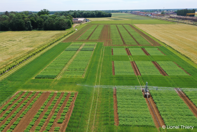
Field experimentation and laboratory: drones and sensors are being used in trials, together with connected traps (insect yellow traps that signal the presence of insects directly, for example).

Studies: In addition to the new modes of acquiring reference data, the many sources of data available are making it possible to address problems without necessarily having to perform new experiments, particularly for subjects linked to long time scales or broad physical scales (landscapes) and for subjects such as agroecology.

Development activities and advising farmers at plot scale: the development activities of the institute and the products and services offered to farmers will evolve significantly through the development of these technologies.

Contact : Frédéric Salvi

f.salvi@terresinovia.fr
Our goals

To exploit new technologies to develop our capacity to acquire reference data, by replacing biometric measurements or complementing them with indirect measurements (remote sensing) in the field.

To centralize, share and valorize all the technical data of the institute more effectively, through the monitoring of plots and plans for surveys and experimentation. One of our objectives is to make all reference data easy to identify, accessible, interoperable and reusable.

To develop new products and services for farmers, through the dynamic monitoring of crops in real time, for example, which has been made possible by the development of remote sensing by satellite and the use of connected objects.

Our main actions

Digital rapeseed: towards the dynamic monitoring of winter rapeseed at the regional scale

Terres Inovia is leading this project bringing together several organizations specializing in agronomy, remote sensing and digital technology. The aim of this project is to construct a pilot real-time monitoring system for the entire growth cycle of rapeseed, based on the use of satellite sensors and connected objects.

Different types of users are envisaged: farmers, for the monitoring of plots on their farms, agricultural agricultural advisers, for spatial inventories of the crops grown in their areas of activity, and cooperatives, to provide a territorial view of production.

A more effective and reliable integrated data management system

The RnDExperience® software suite is a tool for experimental data management used by Terres Inovia. Almost 85% of its experimental activities are processed with this software suite, corresponding to about 140 protocols and 550 trials performed internally or in partnership every year, and millions of items of data.

Since 2015, Terres Inovia has progressively invested in RnDExp Mobile, data input software designed for use in the field. Deployed by Doriane since 2016, this software makes it possible to synchronize data input in the field automatically with a central database, facilitating the integrated management of these data “from the field to technical reference”.

A new mixed technological unit (UMT) in modeling and digital technology

The institute is the chief overseeing body for a new mixed technological unit (UMT) that received French Ministry of Agriculture accreditation for five years in 2017. This project, christened UMT Magnum (modeling and digital agriculture), brings together Terres Inovia, AgroParisTech, INRA*, Arvalis - Institut du végétal and CentraleSupélec. Its aim is to increase our capacity to model cropping systems in the north of France.

Its work is organized around four axes:

- The improvement and use of models for tactical and strategic decision-making,

- The organization of training for actors from the agricultural world, technical institutes and students from AgroParisTech and CentraleSupélec,

- The design and implementation of digital tools in the framework of pilot operations,

- The use and valorization of models for more long-term needs.

The implementation of these axes will necessitate means of processing large amounts of data and the acquisition of new essential skills.

Decision-making rules and decision support systems (DSS) directly accessible to all

Terres Inovia has, for many years, been involved in the development of decision support systems (DSS) and calculators (e.g. the rapeseed nitrogen calculator) for refining cropping practices. One of the major issues at stake is the development of interoperability between these tools for our ecosystem. This work has already begun. Ultimately, our tools will be available online for use via diverse channels (e.g. website, smartphone application) and will be accessible to all our partners.

Collect, share and value data

For the past few years, Terres Inovia has been using applications from ESRI, a company specializing in Geographic Information Systems (GIS), and more specifically the ArcGIS Online portal combined with Survey123. It offers a simple and intuitive data collection solution centered on forms for the creation, sharing and analysis of surveys.  

More than 100 forms have thus been created since 2016 within Terres Inovia to collect information. Some are public and put online on the institute's website, in order to identify the presence and monitor the spread of pests (hernia, orobanches, bird damage) on the French territory.  Others are shared with Terres Inovia's partners to collect information within the framework of partnership projects, or only internally to record directly the observations made in the field.

The choice of this software solution allows to collect data, to value them in real time and to share them through dashboards that can be consulted online. More than 30 dashboards have already been created for internal or external use.